Cherokee Outlet
 On December 29, 1835, an agreement was reached at New Echota, Georgia, between commissioners of the United States and leaders of the Eastern Cherokees. In part, the agreement defined land known as the Cherokee Outlet and provided an assurance to the Cherokee Nation of a " perpetual outlet west." The strip of land, running west of the 96th meridian and approximately 57 miles wide, became commonly known as the Cherokee Strip*.
After the end of the Civil War, a new treaty with the Cherokee Nation provided for the settling of friendly Indian tribes, such as the Osage, Kaw, Ponca, Pawnee, Nes Perce, Otoe-Missouria, and Tonkawa, on land in the eastern part of the Outlet. The Cherokee Strip Livestock Association leased the excellent grasslands in the western part of the Outlet from the Cherokee Nation. Cattlemen fattened huge herds of cattle on the Cherokee lands before finishing their cattle drives from Texas to the Kansas railheads.
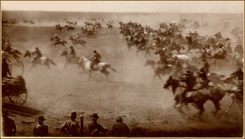
Cherokee Strip Land Run
 A portion of the original Cherokee Outlet was opened by land run in 1893. This opening was the fourth, and largest, of Oklahoma's five land runs. According to President Cleveland, " The Run " would take place at 12 o'clock noon on September 16, 1893. Oral tradition claims that a nervous soldier accidentally discharged his gun at 11:55 a.m. and the race was on! By horse, train, wagon and on foot more than 100,000 land hungry pioneers raced for 40,000 homesteads and the valuable town lots available in the Cherokee Outlet Land Opening. Immigrants from almost every area of the United States and many foreign countries took part in this epic event.

Click image for resizeable view
* The "Real" Cherokee Strip.
Beginning in 1828, the United States and the Cherokee people entered into a series of treaties that set the boundaries of the Cherokee lands in the West. As part of these treaties, the Cherokee were given land in northeastern Oklahoma and the Cherokee Outlet, "a perpetual outlet west." These new lands were to belong to the Cherokees "forever" and were never to be "placed . [under] the jurisdiction of a Territory or State." The original survey of the Cherokee's western land was made under the direction of Isaac McCoy in 1837.
In 1854, the Kansas-Nebraska Act fixed the southern line of Kansas at the 37th meridian. This line was about two and one-half miles south of the original survey line that defined the north boundary of the Cherokee land. This narrow strip of land was the "real" Cherokee Strip.
The Cherokee Nation claimed this narrow strip because it was granted to them in the original survey. Kansas claimed the land because of Federal Law. The strip of land was eventually sold to settlers and the proceeds invested to benefit the Cherokee people.
After the Civil War and the Reconstruction Treaties of 1866, the Cherokee Outlet was increasingly used as grazing land for cattle and at some point became erroneously known as the Cherokee Strip . The Cherokee Nation eventually leased the Outlet to the Cherokee Strip Livestock Association. In 1893 the Outlet was opened to homesteaders in the largest of Oklahoma 's five land runs.
